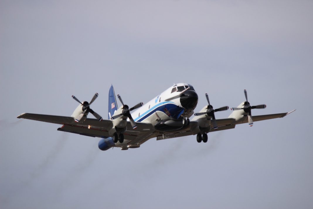
There are not many planes that have the job of the Lockheed WP-3D Orion. This aircraft flies into the eyes of hurricanes to help forecasters and scientists gather data. There are only two units of this turboprop in the world, and they are still being deployed ever since their introduction in 1976.

Essential role
According to the National Oceanic and Atmospheric Administration (NOAA), these planes conduct low-altitude data collection. Ultimately, they fill in gaps in data not available from radar or satellite imagery that is looked at from the ground.
The model was derived from the Lockheed P-3 Orion, which is a four-engine turboprop that was introduced in 1959. This predecessor was an anti-submarine and maritime surveillance aircraft.
The WP-3D has a payload of 62,000 lbs and a gross takeoff weight of 135,000 lbs. Additionally, it can reach speeds between 170 and 250 knots.
The two units equipped with nifty scientific tools, such as radars and recording systems. These measure the atmosphere, the earth, and its environment. Their reliability has meant that they have been in action for 44 years.
Altogether, they are integral in motioning and analyzing hurricanes and other severe storms. They also look at the quality of the atmosphere, oceanographic conditions, and climate trends.

Long-term commitment
The two sides planes are affectionally called Miss Piggy (registration N43RF) and Kermit (registration N42RF), after the Muppet characters. Moreover, they were given logos that resemble the two figures. Another NOAA hurricane hunting aircraft, the Gulfstream IV-SP, has been given the name Gonzo, which is another Muppet character.
The aircraft have been on some crucial projects over the years. Crews have deployed them on several research expeditions across the United States and the globe. They have been useful in cold climates such as around the Arctic Ocean and Alaska. However, they have also been helpful in warmer regions, such as the Caribbean, Gulf of Mexico, and the Eastern Pacific.
Further away from home, they have been part of various experiments in the Indian Ocean, Australia, and the Solomon Islands. They have even been to the Alps, Ireland, and the North Sea.
In total, 20 people can board the WP-3D. Two pilots, a flight engineer, a navigator, a flight director, two engineering/electronics specialists, a radio/avionics specialist, and up to 12 scientists can fit in.

Intricate process
These professionals work together to gather the best data possible within the storm environment. The NOAA shared that the crew deploys expendable probes called GPS dropwindsondes through a launch tube in the plane. While they parachute to the sea below, the probes transmit pressure, temperature, humidity, wind speed, and wind direction data back to the workers.
The data is then checked over to see how accurate it is. After that, it is transmitted from the turboprop to the National Centers for Environmental Prediction and the National Hurricane Center for inclusion into global and hurricane models.
Additionally, the plane can deploy airborne expendable bathythermographs. These are small torpedo-shaped devices that hold temperature sensors and transducers. Ultimately, they can measure the temperature profiles of the ocean.
Furthermore, the aircraft are fixed with lower fuselage radars, which scan storms horizontally. Meanwhile, Doppler radars scan vertically. This type of radar usually allows for the measurement of the wind components toward and away from the system.
Combined, the two systems provide scientists and forecasters a transparent look at the storm. They can see several layers and the internal structure. Above all, the WP-3D Orions are the only planes in the US’ hurricane hunter fleet with these radar systems.
The instrumentation does not stop there. The units are additionally equipped with Step Frequency Microwave Radiometers (SFMRs). The NOAA developed these tools, and the group states that they use them to sense wind speed at the surface of the ocean.
They do this process by measuring and computing radiation emitted by seafoam that is created by the high winds at the surface. Altogether, this information obtained is vital to researchers at the National Hurricane Center for forecasting storms.

Still going strong
Just before the summer, the NOAA shared a press release highlighting the importance of keeping vigilant during hurricane season. In the statement, US Secretary of Commerce Wilbur Ross spoke about the essential role of the group and its equipment.
“As Americans focus their attention on a safe and healthy reopening of our country, it remains critically important that we also remember to make the necessary preparations for the upcoming hurricane season,” Ross said, as per the press release.
“Just as in years past, NOAA experts will stay ahead of developing hurricanes and tropical storms and provide the forecasts and warnings we depend on to stay safe.”
Meanwhile, Neil Jacobs, Ph.D., acting NOAA administrator, shared that his organization’s analysis of current and seasonal atmospheric conditions reveals a recipe for an active Atlantic hurricane season this year. He concluded that his team will provide accurate and timely forecasts to protect life and property.
Therefore, despite its age, the WP-3D Orion still has an essential role in society. Its efforts are part of an initiative to help reduce the impact of natural disasters. Their reliability has ensured that there is another 10 to 15 years of work left for the two units.
What are your thoughts about the Lockheed WP-3D? Had you heard of this aircraft before? Let us know what you think of the plane in the comment section.
[ad_2]
Source link


